- For Sale Subject To Offer
- Property Type VacantLand
- Property Size 192,971 SF
- Lot Size 4.43 Acre
- Property Tenancy Single Tenant
- Date Updated Dec 11, 2024
Reach out to the broker for more info on lease terms and amenities
Attachments
Highlights
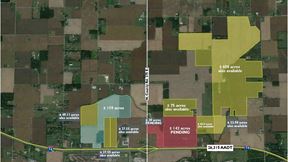
- Agricultural zoned site and homestead lot adjacent to industrial I-65 Anson Planned Unit Development district
- Site within Anson at Allpoints Industrial Park in Whitestown with several large industrial users
- Target end user is industrial owner/user or a speculative building development that would complement surrounding businesses
- Site is situated in the path of progress and one of the fastest growing counties in Indiana and the United States
- Excellent proximity to and minutes from a future interstate exit, as well as nearby amenities such as truck stops, retail, commercial, and housing districts.
False
Contacts
Location
Getting Around
-
Walk Score ®
3/100 Car-Dependent
-
Bike Score ®
29/100 Somewhat Bikeable
- City Whitestown, IN
- Zip Code 46075
- Market Indianapolis
Points of Interest
-
Love's
1.48 miles
-
Circle K
2.06 miles
-
Marathon
2.10 miles
-
Tesla Supercharger
2.13 miles
-
Meijer
2.15 miles
-
GetGo
2.48 miles
-
Speedway
5.08 miles
-
Pilot
6.83 miles
-
BP
7.03 miles
-
Genesys Car Charging Station
7.85 miles
-
Starling Nature Sanctuary Eagle Creek Park
6.88 miles
-
Employee & Visitor Parking
7.05 miles
-
Loading zone
7.84 miles
-
Carmel Clay Community Soccer Complex Parking Lot
8.37 miles
-
truck/bus parking
8.37 miles
-
WoodSpring Suites Indianapolis Zionsville
1.57 miles
-
Hampton
1.96 miles
-
Holiday Inn Express
1.99 miles
-
Eagle Creek Retreat
6.95 miles
-
Extended Stay America - Indianapolis - West 86th St.
7.01 miles
-
Fairfield Inn & Suites Indianapolis Northwest
7.10 miles
-
InTown Suites Extended Stay Indianapolis IN - Traders Point
7.14 miles
-
Sybaris Indianapolis
7.37 miles
-
Lilly Lodge
7.93 miles
-
Quality Inn & Suites Brownsburg - Indianapolis West
7.94 miles
-
Moontown Brewing Company
1.81 miles
-
Harmony Steakhouse
1.88 miles
-
Culver's
1.97 miles
-
City Barbeque
1.98 miles
-
Panera Bread
1.98 miles
-
Qdoba
1.99 miles
-
Wendy's
1.99 miles
-
Chick-fil-A
2.02 miles
-
Denny's
2.02 miles
-
Jimmy John's
2.08 miles
-
Central School
1.87 miles
-
Zionsville West Middle School
2.08 miles
-
Howard School
3.11 miles
-
Trailside Elementary
3.18 miles
-
Zionsville High School Baseball & Softball Complex
3.28 miles
-
Pleasant View Elementary School
4.42 miles
-
Zionsville Middle School
4.63 miles
-
Zionsville Community High School
5.19 miles
-
Eagle Elementary School
5.56 miles
-
Stokes Elementary School
6.15 miles
-
KinderCare
2.52 miles
-
Maria Montessori International Academy
7.21 miles
-
Primrose School at Westclay
8.58 miles
Frequently Asked Questions
The sale price for 5317 E. 450 S. is available upon request. Contact the listing broker for more information.
5317 E. 450 S. totals 192,971 square feet.
Looking for more in-depth information on this property? Find property characteristics, ownership, tenant details, local market insights and more. Unlock data on CommercialEdge.

Bradley Company


