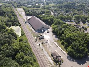
- For Sale Contact for pricing
- Property Type VacantLand
- Property Size 353,271.6 SF
- Lot Size 8.11 Acre
- Additional Rent Contact for pricing
- Year Built 1986
- Date Updated Oct 18, 2024
- Highly visible and accessible site to Interstate 694 at Highway 61 - The City of Vadnais Heights is open to a variety of uses for the site - Tax increment financing (TIF) is available for the development of the site - Utilities to the site will be available via the City of Maplewood - The westerly border sites adjacent to a 3+ acre vacant MNDOT site - The easterly border sits adjacent to the 7.6-mile Bruce Vento walking and biking trail system - The Seller’s will retain the billboard signage rights on the NE corner of the site as shown on the cover page with a red dot
Want more info on this listing?
Reach out to the broker for more info on lease terms and amenities
False
Contacts
Location
Getting Around
-
Walk Score ®
60/100 Somewhat Walkable
-
Transit Score ®
41/100 Some Transit
-
Bike Score ®
57/100 Bikeable
- City Vadnais Heights, MN
- Neighborhood Hazelwood
- Zip Code 55109
- Market Minneapolis St Paul
Points of Interest
-
Saint Paul Union Depot
6.91 miles
-
Central Station
7.11 miles
-
Dale Street
7.54 miles
-
Lexington Parkway
8.24 miles
-
Hamline Avenue
8.61 miles
-
Fairview Avenue
9.42 miles
-
Freedom
0.84 miles
-
Costco Gasoline
1.05 miles
-
Speedway
1.90 miles
-
Holiday
2.10 miles
-
Fleet Farm GasMart
2.54 miles
-
BP
3.34 miles
-
Clark's
3.47 miles
-
ChargePoint
5.71 miles
-
Tesla Supercharger
5.80 miles
-
Maplewood Mall Transit Center
0.55 miles
-
Lot C
0.64 miles
-
Lot B
0.64 miles
-
Lot D
0.71 miles
-
Lot A
0.76 miles
-
Lot E
0.81 miles
-
Highway 61 & County Road C Park & Ride
1.85 miles
-
Hmong Alliance Church
1.99 miles
-
Gateway Trail Parking
2.08 miles
-
Handicap Parking
2.62 miles
-
Emerald Inn
0.39 miles
-
Fairfield Inn & Suites
1.80 miles
-
Comfort Inn & Suites St. Paul Northeast
1.91 miles
-
Northernaire Motel
2.14 miles
-
Kingsbeck Home
3.17 miles
-
Best Western Plus
3.84 miles
-
DoubleTree by Hilton St. Paul East
6.09 miles
-
Hilton Garden Inn Minneapolis St. Paul-Shoreview
6.17 miles
-
Quality Inn & Suites Arden Hills - Saint Paul North
6.33 miles
-
SpringHill Suites by Marriott St. Paul Arden Hills
6.39 miles
-
Chipotle
0.18 miles
-
Taco Bell
0.18 miles
-
Wendy's
0.21 miles
-
Arby's
0.24 miles
-
TGI Friday's
0.25 miles
-
Culver's
0.31 miles
-
Subway
0.31 miles
-
Chick-fil-A
0.32 miles
-
Denny's
0.35 miles
-
Pizza Hut
0.39 miles
-
Richardson Elementary School
1.64 miles
-
North St. Paul Schools
1.91 miles
-
Century College
2.00 miles
-
John Glenn Middle School
2.26 miles
-
Weaver Elementary School
2.32 miles
-
Webster Elementary School
2.49 miles
-
Castle Elementary School
2.79 miles
-
Maplewood Middle School
2.88 miles
-
Mounds Park Academy
2.90 miles
-
Birch Lake Elementary School
3.19 miles
-
Primrose School of Arden Hills and Shoreview
6.41 miles
-
Rainbow Child Development Center
6.81 miles
-
Hodan Childcare Center
8.03 miles
-
St. Paul's Childcare Center
8.68 miles
-
Growing Genration CDC
8.78 miles
-
Primrose School
8.89 miles
-
New Horizon Academy
9.00 miles
-
St. Anthony Park
9.24 miles
-
Pathways to Play
9.26 miles
-
Kinderberry Hill Child Development Center
9.31 miles
Frequently Asked Questions
How much does County Road D E & Maplewood Dr cost?
The sale price for County Road D E & Maplewood Dr is available upon request. Contact the listing broker for more information.
What is the total square footage of County Road D E & Maplewood Dr?
County Road D E & Maplewood Dr totals 8 square feet.
When was this property built?
County Road D E & Maplewood Dr was built in 1986.
Looking for more in-depth information on this property?
Looking for more in-depth information on this property? Find property characteristics, ownership, tenant details, local market insights and more. Unlock data on CommercialEdge.


