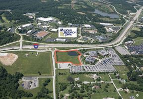
- For Lease $7.25/SF/YR
- Property Type Industrial
- Property Size 18,195 SF
- Lot Size 0.98 Acre
- Building Class C
- Year Built 1977
- Date Updated Jan 23, 2025
Reach out to the broker for more info on lease terms and amenities
True
Spaces Available
#670 |
|
Location
Getting Around
-
Walk Score ®
23/100 Car-Dependent
-
Transit Score ®
21/100 Minimal Transit
-
Bike Score ®
37/100 Somewhat Bikeable
- City Chesterfield, MO
- Zip Code 63005
- Market St Louis
Points of Interest
-
Phillips 66
0.98 miles
-
BP
0.99 miles
-
Wild Horse Mobil
1.17 miles
-
Circle K
3.90 miles
-
QuikTrip
4.00 miles
-
Mobil
4.03 miles
-
EVgo Charging Station
8.37 miles
-
Tesla Supercharger
9.60 miles
-
Electrify America
9.84 miles
-
Monarch Chesterfield Levee Trail Parking
2.24 miles
-
Monarch-Chesterfield Levee Trail Parking
3.17 miles
-
Commuter Lot: US 40 and MO 94 East
4.16 miles
-
Commuter Lot: US 40 and MO 94 West
4.47 miles
-
Hamburg Trail trailhead
5.29 miles
-
Robin Park parking
5.32 miles
-
Lot 8
5.55 miles
-
Lot 7
5.55 miles
-
Lot 9
5.56 miles
-
Lot 6
5.58 miles
-
Vito's in the Valley
0.88 miles
-
Valley Wok
0.89 miles
-
McDonald's
0.96 miles
-
Schlotzsky's
0.98 miles
-
Scarecrow
0.99 miles
-
Wendy's
1.32 miles
-
Espino's
1.42 miles
-
Babbo's Spaghetteria
1.45 miles
-
Hardee's
1.62 miles
-
Chick-fil-A
1.63 miles
-
Saks Off 5th
1.51 miles
-
Burlington
1.56 miles
-
St. Louis Premium Outlets
1.58 miles
-
ALDI
1.67 miles
-
Walmart Supercenter
2.34 miles
-
Target
2.65 miles
-
Macy's
3.86 miles
-
Chesterfield Mall
3.93 miles
-
Trader Joe's
4.01 miles
-
Dierbergs
4.17 miles
-
Walgreens
0.87 miles
-
Passport Health Chesterfield Travel Clinic
1.72 miles
-
Sam's Club Pharmacy
2.06 miles
-
Cottleville Fire Protection District Station 4
3.81 miles
-
Chesterfield Police Station
3.82 miles
-
Missouri State Highway Patrol Troop C
4.18 miles
-
Walgreens Pharmacy
4.19 miles
-
Monarch Fire Protection District House 1
4.25 miles
-
Cottleville Fire Protection District Station 3
4.35 miles
-
Progress West Hospital
4.77 miles
Frequently Asked Questions
The average rental rate for industrial/warehouse space at 670-672 Goddard Ave is $7.25/SF/YR. Generally, the asking price for warehouse spaces varies based on the location of the property, with proximity to transportation hubs, access to highways or ports playing a key role in the building’s valuation. Other factors that influence cost are the property’s age, its quality rating, as well as its onsite facilities and features.
The property at 670 Goddard Ave was completed in 1977. In total, 670-672 Goddard Ave incorporates 18,195 square feet of Industrial space.
For more details on this listing and available space within the building, use the contact form at the top of this page to schedule a tour with a broker.
Contact the property representative for more information on vehicle access and parking options at or near this property, as well as additional amenities that enhance the tenant experience at 670 Goddard Ave.
Reach out to the property representative or listing broker to find out more about climate control capabilities at this property. Climate control is typically present in industrial buildings that are suited to store items susceptible to temperature and damage from humidity, such as food, pharmaceuticals, paper, textiles, and electronics.
Looking for more in-depth information on this property? Find property characteristics, ownership, tenant details, local market insights and more. Unlock data on CommercialEdge.


