- For Sale $3,300,000
- Property Type VacantLand
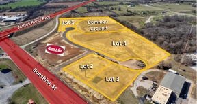
- Lot Size 100.22 Acre
- Date Updated Jan 23, 2025
Reach out to the broker for more info on lease terms and amenities
Attachments
Highlights
- First time to market
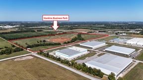
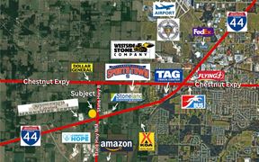
- Located immediately adjacent to 1.3M SF Amazon Fulfillment Center
- Easy access to I-44, Hwy 60 and James River Freeway
- 1.5B in investment in the corridor between now and 2025
- Only available bulk development tract of its kind in Republic Market
- Convoy of Hope World Headquarters - $37M - 650 employees – completed October 2023
- Amazon Fulfillment Center - $150M – 1,800 employees
- Iron Grain mixed-use development $65M – under construction – Spring 2024
- Investment into Infrastructure:
- $12.5M to 5 Lane MM Highway From I-44 to James River
- $35M to realign MM from Amazon South to Highway 60 with a new signalized intersection at Farm Road 103. This intersection will see AM and PM peaks of close to 60k cars a day
- City investing $100M into additional capacity of water and wastewater systems to facilitate further growth and development
False
Contacts
Location
Getting Around
-
Walk Score ®
3/100 Car-Dependent
-
Bike Score ®
25/100 Somewhat Bikeable
- City Republic, MO
- Neighborhood Republic
- Zip Code 65738
Points of Interest
-
Kum & Go (Cars)
0.95 miles
-
Kum & Go (Trucks)
0.97 miles
-
Shell
2.46 miles
-
Conoco (Cars)
2.61 miles
-
Conoco (Trucks)
2.61 miles
-
Murphy USA
2.88 miles
-
Kum & Go
3.57 miles
-
Casey's
3.70 miles
-
Conoco
3.98 miles
-
Ball Fields
1.56 miles
-
Wilson's Creek Trail
3.02 miles
-
1. Gibson's House and Mill
3.29 miles
-
8. Route of Union Advance & Withrawal (Parallel Parking)
3.36 miles
-
7. Bloody Hill and Totten's Battery
3.77 miles
-
2. Ray Farm
3.90 miles
-
Golf Course
4.00 miles
-
Trail Parking (unpaved)
4.01 miles
-
6. Guibor's Battery (Parallel Parking)
4.07 miles
-
Paintball Parking
4.11 miles
-
AmericInn by Wyndham Republic
2.90 miles
-
Best Western Plus Springfield Airport Inn
4.82 miles
-
Best Budget Inn Springfield-Magnuson
4.86 miles
-
Wishing Well Motel
5.59 miles
-
Quality Inn & Suites
5.89 miles
-
Value Place Springfield
5.98 miles
-
The Mansion at Elfindale
6.58 miles
-
Courtyard Springfield Airport
7.17 miles
-
La Quinta Inn & Suites Springfield South
7.26 miles
-
La Quinta Inn & Suites Springfield Airport Plaza
7.29 miles
-
Jeanie's Restaurant
2.22 miles
-
El Charro
2.23 miles
-
Bair's All-American Sports Grill
2.25 miles
-
Arby's
2.56 miles
-
Wendy's
2.61 miles
-
Big Whiskey's American Restaurant & Bar
2.82 miles
-
Papa Murphy's
2.90 miles
-
Diamond Head
2.94 miles
-
Subway
2.96 miles
-
Little Caesars
2.98 miles
-
Republic High School
1.66 miles
-
Republic Middle School
3.41 miles
-
Lyon Elementary School
3.46 miles
-
Price Elementary School
3.58 miles
-
Sweeny Elementary School
3.59 miles
-
Republic Early Childhood Center
3.63 miles
-
Schofield Elementary School
3.75 miles
-
McCulloch Elementary School
3.79 miles
-
Willard Orchard Hills Elementary School
4.10 miles
-
Wilson's Creek School
4.20 miles
-
Hope Childcare Center
3.55 miles
-
Macedonia Pre-School
4.98 miles
-
Safe N Sound Playground
5.30 miles
-
Isabel's House Crisis Nursery
5.62 miles
-
The Goddard School
5.82 miles
-
Where Babies Grow LLC
6.25 miles
-
Creative Learning Center Preschool & Infant Care LLC
7.25 miles
-
OACAC Head Start
7.48 miles
-
Promise Pre-School & Day Care
8.04 miles
-
Cox Health
8.94 miles
Looking for more in-depth information on this property? Find property characteristics, ownership, tenant details, local market insights and more. Unlock data on CommercialEdge.

R.B. Murray Company


