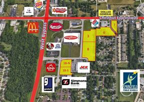
- For Sale $325,000
- Property Type VacantLand
- Lot Size 4.98 Acre
- Date Updated Apr 7, 2025
Reach out to the broker for more info on lease terms and amenities
Highlights
- Tract B (4.98 acres) sale price is $325,000
- Near the Springfield-Branson National Airport.
- Property is currently zoned C-3 (Greene County Zoning), lots will revert to C-2 zoning with sale.
- Both tracts have electrical to the. (City Utilities of Springfield and Greene County are available options)
- New roundabout planned at the Highway 266 and Farm Road 99 intersection
False
Contacts
Location
Getting Around
-
Bike Score ®
32/100 Somewhat Bikeable
- City Springfield, MO
- Neighborhood Republic
- Zip Code 65802
Points of Interest
-
Shell
2.68 miles
-
Flying J's
2.70 miles
-
Casey's
3.70 miles
-
Cenex
3.97 miles
-
Kum & Go
4.55 miles
-
Kum & Go (Cars)
4.59 miles
-
Kum & Go (Trucks)
4.61 miles
-
Eagle Stop
4.68 miles
-
Sinclair
4.77 miles
-
Murphy USA
4.80 miles
-
Golf Course
1.85 miles
-
Paintball Parking
2.08 miles
-
Ball Fields
2.11 miles
-
Cell Phone lot
2.38 miles
-
Long Term C
2.39 miles
-
Short Term B
2.53 miles
-
Rental Car Return
2.55 miles
-
Employee Parking
2.61 miles
-
Trail Parking (unpaved)
3.96 miles
-
Frisco Highline Trail
4.57 miles
-
Best Western Plus Springfield Airport Inn
3.25 miles
-
Best Budget Inn Springfield-Magnuson
3.29 miles
-
Wishing Well Motel
4.40 miles
-
Courtyard Springfield Airport
4.90 miles
-
La Quinta Inn & Suites Springfield Airport Plaza
5.07 miles
-
AmericInn by Wyndham Republic
6.00 miles
-
The Mansion at Elfindale
6.78 miles
-
Anglers Inn
7.55 miles
-
Quality Inn & Suites
7.61 miles
-
Moxy Springfield Downtown
7.63 miles
-
Wendy's
2.67 miles
-
I Love Tacos Taqueria
2.75 miles
-
Alli's Family Restaurant
3.15 miles
-
Plaza Mexico
3.51 miles
-
Subway
4.02 miles
-
Sonic
4.39 miles
-
Taco Bell
4.43 miles
-
McDonald's
4.45 miles
-
Burger King
4.47 miles
-
Cedars Family Restaurant
4.47 miles
-
Willard Central Elementary School
2.33 miles
-
OACAC West Chestnut Head Start
2.61 miles
-
Willard Orchard Hills Elementary School
3.31 miles
-
Willard South Elementary School
3.84 miles
-
Westport Elementary School
4.98 miles
-
Bissett Elementary School
5.16 miles
-
Bissett School
5.19 miles
-
Republic High School
5.24 miles
-
Carver Middle School
5.65 miles
-
York Elementary School
5.80 miles
-
Macedonia Pre-School
5.39 miles
-
Isabel's House Crisis Nursery
5.59 miles
-
Hope Childcare Center
6.47 miles
-
Safe N Sound Playground
6.68 miles
-
Where Babies Grow LLC
7.28 miles
-
OACAC Head Start
7.30 miles
-
The Goddard School
7.69 miles
-
Cox Health
7.79 miles
-
Creative Learning Center Preschool & Infant Care LLC
7.99 miles
-
OTC Early Childhood Education Center (ECEC)
8.41 miles
Looking for more in-depth information on this property? Find property characteristics, ownership, tenant details, local market insights and more. Unlock data on CommercialEdge.

SVN | Rankin Company

