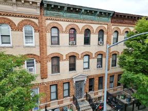
- For Sale $3,150,000
- Property Type Unassigned
- Property Size 20,081 SF
- Lot Size 0.15 Acre
- Year Built 1930
- Date Updated Mar 31, 2025
The property has a total of 21 units; 17 residential and 4 commercial. Of the 17 residential units, 15 are one-bedroom and 2 are two-bedrooms. The property offers extremely convenient access to major roads such as the New England Thruway, Hutchinson River Parkway, and the Bronx River Parkway and benefits from its accessibility via the numerous bus routes that canvass the area.
Reach out to the broker for more info on lease terms and amenities
False
Contacts
Location
Getting Around
-
Walk Score ®
77/100 Very Walkable
-
Transit Score ®
83/100 Excellent Transit
-
Bike Score ®
69/100 Bikeable
- City Bronx, NY
- Neighborhood Williamsbridge
- Zip Code 10469
- Market Bronx
Points of Interest
-
Gun Hill Road
0.59 miles
-
Williams Bridge
0.85 miles
-
Baychester Avenue & Tillotson Avenue (Exit only)
1.00 miles
-
Norwood–205th Street
1.21 miles
-
233rd Street
1.32 miles
-
Woodlawn
1.46 miles
-
Mosholu Parkway
1.56 miles
-
Bedford Park Boulevard
1.64 miles
-
Bedford Park Blvd.
1.66 miles
-
Bedford park Blvd.
1.68 miles
-
Gulf
1.20 miles
-
Mobil
1.23 miles
-
Shell
1.25 miles
-
76
1.38 miles
-
Tesla Supercharger
1.61 miles
-
Speedway
1.74 miles
-
BP
1.84 miles
-
plugNYC
8.24 miles
-
ChargePoint
8.40 miles
-
FLO
8.74 miles
-
Peter Jay Sharp Building
1.50 miles
-
Parking Area A
1.66 miles
-
Fordham Regional Parking Facility
1.71 miles
-
Bronx River Parking
1.72 miles
-
Southern Boulevard Parking
2.15 miles
-
Asia Parking
2.20 miles
-
Jerome – 190th Street Municipal Parking Garage
2.44 miles
-
Broadway Parking Garage
2.49 miles
-
Metropolis
2.58 miles
-
Chang Li Supermarket Inc.
2.72 miles
-
Crown Motor Inn
0.18 miles
-
El Rancho Motel
0.69 miles
-
Days Inn
0.86 miles
-
Rodeway Inn
1.19 miles
-
Ramada
1.33 miles
-
Pelham Garden Motel
1.58 miles
-
Residence Inn The Bronx
1.82 miles
-
Bronx Park Motel
1.83 miles
-
Metro Motel
2.06 miles
-
Hutchinson - Whitestone Motel
2.33 miles
-
McDonald's
0.22 miles
-
Top of the Hill Cuisine
0.42 miles
-
Golden Krust Caribbean Restaurant
0.62 miles
-
Domino's
0.63 miles
-
Bella Napoli
0.76 miles
-
Al's Famous Pizza & Restaurant
0.76 miles
-
Dream Station
0.76 miles
-
Smile Restaurant
0.76 miles
-
Allerton Restaurant
0.77 miles
-
Agra Grill
0.80 miles
-
Saints Philip and James School
0.17 miles
-
Bronx Aerospace High School
0.31 miles
-
Community High School of Social Justice
0.31 miles
-
High School of Contemporary Arts
0.31 miles
-
Immaculate Conception Parochial School
0.43 miles
-
Public School 76 The Bennington School
0.46 miles
-
School of Diplomacy
0.49 miles
-
Public School 113
0.50 miles
-
Lavelle School for the Blind
0.53 miles
-
Public School 121
0.57 miles
-
Mama Maria's Group Family Daycare
2.12 miles
-
Children's Learning Company
2.57 miles
-
Tig and Peach
3.34 miles
-
Pelham Children's Center
3.52 miles
-
East Bronx NAACP Day Care Center
3.58 miles
-
Junior Wonders Nursey School
3.58 miles
-
Reformed Church Nursery School
4.45 miles
-
Prospect Family Support Center
4.61 miles
-
Salvation Army: Bronx Citadel
4.64 miles
-
Incarnation Children's Center
4.74 miles
Frequently Asked Questions
The space currently listed for sale at 1053-1059 East Gun Hill Road, Bronx, NY 10469 asks for $3,150,000.
1053-1059 East Gun Hill Road, Bronx, NY 10469 totals 20,081 square feet.
1053-1059 East Gun Hill Road, Bronx, NY 10469 was built in 1930.
Looking for more in-depth information on this property? Find property characteristics, ownership, tenant details, local market insights and more. Unlock data on CommercialEdge.


