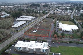
Industrial Land West of Main Street

Industrial Land West of Main Street, Banks, OR 97106

  • For Sale $5.00/SF
  • Property Type VacantLand
  • Lot Size 6.5 Acre
  • Additional Rent Contact for pricing
  • Date Updated Dec 11, 2024
The city of Banks is located among farms and near forest in Washington County’s Tualatin Valley between Portland and the Oregon Coast. Situated where Oregon State Route 6 and Oregon Route 47 intersect, Banks is 24 miles northwest of Downtown Portland via Highway 26. Three of the most popular tourist destinations on the Oregon Coast are easily accessible from Banks: Tillamook is a 50-minute trip via Highway 6, and Cannon Beach and Seaside are a 1-hour drive via Highway 26. A rural community of nearly 1,900, with a significant forest products manufacturing base, Banks is experiencing growth due to the Portland Metro Area’s rapid expansion and the booming high-tech industry in nearby Hillsboro and Forest Grove. Banks is just 11 miles from three Intel Corporation campuses, including Ronler Acres, their largest facility in the United States; and is just seven miles from Pacific University in Forest Grove. Banks is the southern anchor and trail head for the dramatic 21-mile Banks-Vernonia State Trail – on a former rail route – popular among cyclists, horseback riders and hikers; and is the connection point to the 30-mile Tualatin Valley Scenic Bike-way. Quail Valley Golf Course is minutes away.±6.5 Acre Parcel in Banks, OR Located One Block West of NW Main Street in Banks, OR This hard-to-find industrial land was annexed into the city in 2017 with an industrial overlay designation and can be partitioned into smaller parcels. The site will have access via Wilkes Street. Direct access to the site off Highway 26 is minutes from Hillsboro, North Plains, and Forest Grove.
Want more info on this listing?

Reach out to the broker for more info on lease terms and amenities

Attachments

Highlights

  • Hard to find Industrial land
  • Annexed into the city in 2017
  • Industrial Overlay designation
  • Access via Wilkes Street
  • Utilities in NW Main Street
  • Direct access off Highway 6, minutes to Hillsboro, North Plains, Beaverton, and Forest Grove

Contacts

broker

Capacity Commercial Group

Location

Getting Around

  • Walk Score ®

    58/100 Somewhat Walkable
  • Bike Score ®

    61/100 Bikeable
Powered by Walk Score ®
  • City Banks, OR
  • Neighborhood Banks
  • Zip Code 97106
  • Market Portland

Points of Interest

  • Chevron

    0.26 miles

  • Shell

    0.51 miles

  • Time

    5.84 miles

  • Arco

    5.93 miles

  • ampm

    5.94 miles

  • Cheveron

    6.54 miles

  • Electrify America

    6.79 miles

  • Blink

    7.01 miles

  • ChargePoint

    9.09 miles

  • Sunset Speedway Parking

    0.20 miles

  • Overflow Parking

    0.51 miles

  • Banks-Vernonia Parking

    0.56 miles

  • Cart Parking

    0.57 miles

  • M-Lot

    6.16 miles

  • L-Lot

    6.19 miles

  • J-Lot

    6.21 miles

  • K-Lot

    6.23 miles

  • E-Lot

    6.32 miles

  • Lot-N

    6.34 miles

  • Americas Best Value Inn

    6.64 miles

  • Best Western

    6.70 miles

  • Hillsboro Budget Inn

    9.11 miles

  • The Dunes Motel

    9.53 miles

  • Staybridge Suites

    9.87 miles

  • Subway

    0.32 miles

  • Oriental Garden

    0.33 miles

  • Mainstreet Pizza

    0.33 miles

  • Eazy Peazy Eatz

    0.42 miles

  • Mary’s Bar & grill

    3.95 miles

  • DQ Grill & Chill

    4.46 miles

  • McDonald's

    5.89 miles

  • Taco Bell

    5.91 miles

  • Old Hichen Post

    5.95 miles

  • King Torta

    5.96 miles

  • Banks Junior High School

    0.06 miles

  • Banks High School

    0.16 miles

  • Banks Elementary School

    0.17 miles

  • Saint Francis of Assisi School

    2.17 miles

  • Visitation Catholic School

    4.58 miles

  • North Plains Elementary School

    5.23 miles

  • Forest Grove High School

    5.53 miles

  • Harvey Clark Elementary School

    6.05 miles

  • Banks Christian Academy

    6.24 miles

  • Pacific University

    6.29 miles

  • Oregon Child Development Coalition

    7.37 miles

  • Zion Lutheran Preschool

    7.37 miles

  • Calvary Lutheran Preschool

    8.63 miles

Frequently Asked Questions

How much does Industrial Land West of Main Street cost?

The sale price for Industrial Land West of Main Street is available upon request. Contact the listing broker for more information.

Looking for more in-depth information on this property?

Looking for more in-depth information on this property? Find property characteristics, ownership, tenant details, local market insights and more. Unlock data on CommercialEdge.

Contact Listing Broker
broker

Capacity Commercial Group