- For Sale Subject To Offer
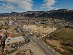
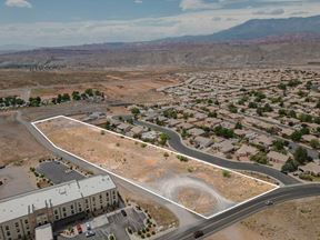
- Property Type VacantLand
- Property Size 364 SF
- Units 3
- Lot Size 5 Acre
- Year Built 1965
- Date Updated Mar 31, 2025
Reach out to the broker for more info on lease terms and amenities
Attachments
False
Contacts
Location
Getting Around
-
Walk Score ®
27/100 Car-Dependent
-
Bike Score ®
33/100 Somewhat Bikeable
- City La Verkin, UT
- Neighborhood La Verkin
- Zip Code 84745
Points of Interest
-
Sinclair
0.96 miles
-
Maverik
1.49 miles
-
Chevron
1.98 miles
-
Exxon
2.37 miles
-
Venture Fuels
3.40 miles
-
Virgin Comm Const Rally Stop
3.51 miles
-
Purgatory Jail
7.94 miles
-
La Verkin Overlook Trailhead Parking
0.30 miles
-
Cryptobiotic Trailhead Parking
2.37 miles
-
Sand Cove Parking Lot
3.47 miles
-
Toquerville Mine Parking Lot
3.76 miles
-
Babylon Parking Lot
4.08 miles
-
Red Bull Rampage Finish Corral
6.27 miles
-
Red Bull Rampage Finish Corral Arche
6.41 miles
-
Red Bull Rampage Parking Lot
6.43 miles
-
Red Bull Rampage Parking Lot 2001-2004
6.57 miles
-
Gooseberry Mesa - White Trailhead Parking
6.86 miles
-
Zion Inn
0.58 miles
-
Best Western Plus Zion West Hotel
1.08 miles
-
La Quinta Inn & Suites La Verkin-Gateway to Zion
1.10 miles
-
Econo Lodge Hurricane Zion Park Area
1.71 miles
-
Rodeway Inn
1.90 miles
-
Super 8 Hurricane Zion National Park
2.01 miles
-
Wingate by Wyndham Hurricane Near Zion National Park
2.04 miles
-
My Place
2.45 miles
-
Sleep Inn & Suites Hurricane Zion Park Area
3.25 miles
-
Days Inn by Wyndham Hurricane/Zion National Park Area
3.71 miles
-
Stage Coach Grille
0.46 miles
-
El Jinete Mexican Grill
1.55 miles
-
Main Street Cafe
1.71 miles
-
Little Caesars
1.74 miles
-
Alfredo's A Mexican Food
1.79 miles
-
Taco Bell
1.81 miles
-
Las Lupitas Mexican Grill
1.82 miles
-
Subway
1.91 miles
-
Papa Murphy's
1.93 miles
-
JB's Restaurant & Bakery
1.96 miles
-
LaVerkin Elementary School
0.33 miles
-
Hurricane Middle School
1.44 miles
-
Valley Academy Charter School
1.88 miles
-
Hurricane High School
1.93 miles
-
Hurricane Elementary School
1.96 miles
-
Utah Tech University Hurricane Center
2.10 miles
-
Three Falls Elementary School
2.57 miles
-
Hurricane Intermediate School
3.18 miles
-
Diamond Ranch Academy
6.55 miles
-
Dixie Kids
1.54 miles
Frequently Asked Questions
The sale price for Residential Development Land near SR-9 is available upon request. Contact the listing broker for more information.
Residential Development Land near SR-9 totals 364 square feet.
Residential Development Land near SR-9 was built in 1965.
Looking for more in-depth information on this property? Find property characteristics, ownership, tenant details, local market insights and more. Unlock data on CommercialEdge.

NAI Excel


